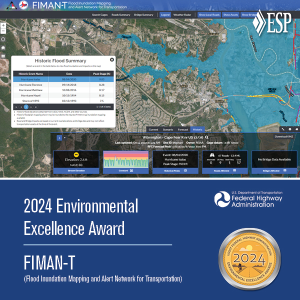
In response to devastating flooding caused by Hurricane Floyd in 1999, the North Carolina Floodplain Mapping Program (NCFMP) was established to better identify, communicate, and manage flood risks throughout the state. To meet this goal, the Flood Inundation Mapping & Alert Network (FIMAN) was developed to provide emergency managers and the public with detailed, real-time rainfall and stream/flood data, thereby reducing loss of life and property damage related to flood.
ESP has been involved with the NCFMP’s flood warning system since its inception in the early 2000s and has a unique and thorough understanding of the underlying database components. ESP led the software development and database design for the current FIMAN enterprise database.
Since its inception, FIMAN has evolved from a network of measurement stations (i.e. gages) that collect rain and stream flow information to a sophisticated system of nearly 550 gages and integrated technologies that collect, analyze, map, and communicate flood risk in real-time via a powerful web interface. To support FIMAN and its sister application (FIMAN-T), ESP has developed more than 250 riverine and coastal map libraries, including more than 100 since 2024 alone.
FIMAN Tools
Automated alert notifications
Integrated third-party systems
Real-time gage data from stream sensors
Live stream of GIS features from real-time data
Emergency operations center report generation
Processing tools to calculate damage at real-time gage heights
Water elevation slider bar to run what-if scenarios for what would be flooded at higher flood levels
Innovative archival and viewing of historic flood inundation and damages
2017 MAPPS Geospatial Excellence Award for GIS/IT
2017 ESRI Special Achievement in GIS Award
Client
North Carolina Emergency Management
Location
Statewide
Status
Application Development: 2009-2017 Data Development: 2009-ongoing