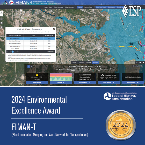
NCDOT Flood Inundation Mapping & Alert Network for Transportation (FIMAN-T)
In 2019, the NC Department of Transportation and NC Emergency Management partnered with ESP to develop the Flood Inundation Mapping and Alert Network for Transportation (FIMAN-T), a web-based tool that supports disaster response and planning during flood events by providing visualization and metrics for real-time and forecasted flood inundation depths along roads, bridges, and other NCDOT assets. ESP pioneered the creation of the initial road inundation layer dataset and designed the additional database tables for bridge freeboard and metric rollups for reporting purposes.
Over the course of two contracts, ESP has expanded the system from a pilot to approximately 100 sites monitoring thousands of miles of roadway and has developed more than 250 riverine and coastal map libraries, including more than 100 since 2024 alone. Inundation libraries include both building-level damage impacts and roadway/bridge impact data. ESP also pioneered the first 2D inundation library. ESP’s innovative enhanced flood warning includes HEC-RAS 2D modeling using a combination of rain-on-grid and steady-state hydrograph techniques to develop inundation libraries for select flood-prone areas with complicated flow patterns.
In 2024, the Federal Highway Administration (FHWA) awarded NCDOT and NCEM with its Environmental Excellence Award, recognizing FIMAN-T as an outstanding transportation project that incorporates environmental stewardship into the planning and development processes. ESP was honored to be named a co-recipient of the award and to serve as partners in FIMAN-T’s continued success.
2024 Environmental Excellence Award, Federal Highway Administration