Mecklenburg County Risk Assessment & Risk Reduction
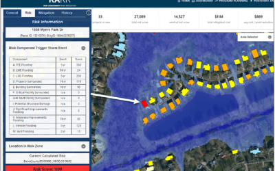
In 2012, Mecklenburg County initiated the Risk Assessment/Risk Reduction (RARR) initiative to help prioritize and guide implementation of flood mitigation projects. In 2018, ESP was selected to support the multi-year collaborative effort between Mecklenburg County and the Department of Homeland Security (DHS) to develop advanced tools within a technology framework to help communities address flood risk. The ongoing effort includes updating and enhancing the county’s RARR system, developing a community flood risk guidebook, and integrating low-cost sensors and gages to provide storm-event flood inundation mapping and impact analysis.
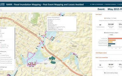
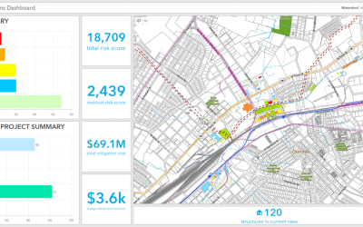
New tools are being developed to create seamless flood inundation boundaries for more than 200 miles of county streams based on gages and sensors to assess impacts to buildings and roads within the county. The guidebook was developed to support the county’s successful flood mitigation program and DHS’ specialized Flood Apex program that develops and applies new and emerging technologies to improve community resilience from flood disasters. Its goals are to reduce fatalities and property losses from future flood events, increase community resilience to disruptions caused by flooding, and develop better investment strategies to prepare for, respond to, recover from, and mitigate against flood hazards.