Beginning in 2009, ESP supported FEMA’s Risk MAP program as a Joint Venture Partner for RAMPP and is currently a major subcontractor to the COMPASS team (both national FEMA providers). We have provided comprehensive services and support for all phases of the National Flood Insurance Program (NFIP) to Regions II, III, IV, VI, VII, and IX. Beginning in 2014 and continuing today, ESP is also providing national support to the COMPASS team for field survey, lidar, H&H engineering, DFIRM, Risk MAP, and Risk MAP products.
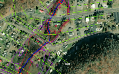
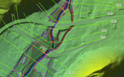
We completed the production of Base Level Engineering (BLE) analysis in FEMA Region VI for two watersheds: Upper Sabine (TX) and Black Lake Bayou (LA). This BLE analysis was part of the Compass Region VI FY20 Regional Task Order and produced 1D BLE analysis for 1,898 stream miles and 2D BLE analysis on approximately 906 sq. mi. study area. The scope included development of terrain data, hydrologic and hydraulics analysis, floodplain mapping, and flood risk products produced in adherence to the latest Region VI BLE deliverable guidance in place.
For this portion of the project, our team received the COMPASS JV High Performing Project Award, alongside project partner Halff Associates. This award is presented quarterly by AECOM/CDM Smith’s Compass Production and Technical Services Joint Venture for projects that provide direct, correlated customer satisfaction.
Through proper planning and execution, ESP also captured data required to complete flood studies on otherwise inaccessible railroad structures using UAV technology. In 2020, as part of the COMPASS team, ESP collected channel cross-sections using conventional survey and UAV’s for FEMA-related projects in Region III, including UAV lidar data and imagery for five restricted-access railroad bridges located over the Falling River and the Roanoke River in Virginia. ESP also used the UAV-extracted information, in conjunction with hydrographic measurements, to obtain the upstream river inverts.
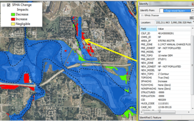
As a JV partner for RAMPP, ESP managed 11 updates to countywide flood studies, including the direction of all associated data development tasks (field survey, topographic data development, hydrologic analysis, hydraulic analysis, floodplain mapping, and FIRM database) as well as preliminary and post-preliminary processing activities. Project scopes included both regulatory and non-regulatory Risk MAP product development and adherence to FEMA quality standards and specifications. Many of these projects were performed in order to incorporate large-scale LOMRs performed by others as Physical Map Revisions into the Effective countywide dataset.