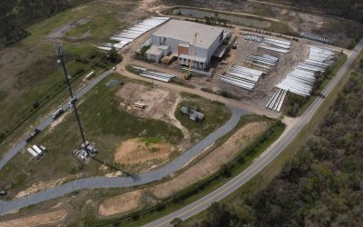
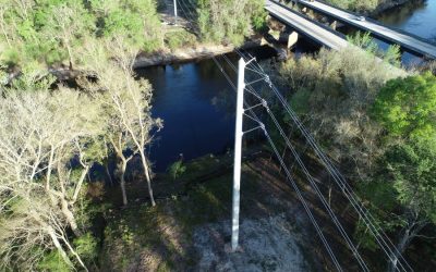
Pickett, an ESP Company, was contracted to provide the overall engineering of a new 176-mile, 161kV transmission line from Raven Substation in Lake City, FL to Sinai Cemetery Substation near Chattahoochee, FL. The project included modifications and expansions of each substation and of the communication repeater station at the transmission line mid-point. The transmission line is designed using major sections of double-bundled 1272 ACSR conductor and a double-circuit section of single 1590 ASCR conductor installed on single-pole steel or spun concrete structures. A variety of structure configurations were employed to address blowout, guying, and ROW constraints.
Multi-disciplinary services also included ROW access design, substation civil and electrical layout and design for a fiber regeneration hut (control house), coordination and oversight of real estate acquisition, surveying, permitting (federal, state, and local), and construction support. Detailed coordination was required across subcontractors, third-party consultants, key stakeholders, and interconnecting co-ops and municipalities.
Construction and outage constraints necessitated an aggressive design schedule, requiring line spotting, real estate acquisition, and environmental permitting to be conducted in parallel while also addressing long lead times on structure procurement and fabrication, foundation design issues, and public outreach due to karst and other poor geological conditions. Design considerations have required performing AC mitigation studies and addressing joint use distribution and fiber communications.
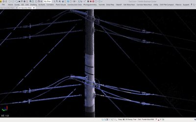
Together, ESP and Pickett provided airborne lidar mapping and survey control services for Phase 2A, a 48-mile portion of the North Florida Resiliency Connection (NFRC). The scope included a 450-foot-wide swath of both lidar and imagery along the proposed corridor. Additionally, ESP provided complete surveying and mapping services on a separate 46-mile section of the NFRC. ESP used a combination of aerial lidar, GPS, robotic total stations, and underground utility locating equipment to collect the required information. The use of aerial lidar and GPS enabled our team to deliver preliminary land base mapping early in the project schedule. Additionally, we used existing ortho-imagery to assist with section and property line ties along the corridor while we acquired the new photography for base mapping.